There are no items in your basket.
Durham County Record Office Online Shop
Publication
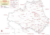
Map of Durham parish and chapelry boundaries, circa 1800
Unfortunately this item is currently not in stock. There is a copy available, for reference only, in the County Record Office.
Publisher:
Durham County Record Office (2001)
Dimensions:
42 x 29.5 cm
A map of ecclesiastical parish boundaries at the beginning of the nineteenth century in the county of Durham and in that part of the North Riding of Yorkshire which was added to Durham in 1974. Inset map of Durham City parishes.